This website uses cookies to ensure you get the best experience on our website.
Layers
Geography/boundary
Coral Triangle Boundary
The Boundary of the Coral Triangle was delineated based on species diversity (corals, reef fishes and other invertebrates: Veron et al, unpublished data), habitat type and diversity, oceanography, geomorphology, bathymetry, sea level fluctuations and river discharge. It comprises all or part of six countries in Southeast Asia and Melanesia: Indonesia, Philippines, Malaysia (Sabah), Timor Leste, Papua New Guinea and the Solomon Islands. This dataset originated from The Nature Conservancy (TNC).
Download Dataset Coral Triangle BoundaryData Sources
CTI-CFF Implementation AreaSummary
FOR USE IN CORAL TRIANGLE PROGRAM MAPS THE FOLLOWING NOTE MUST BE INCLUDED: "Boundaries are only for illustration and are not legally binding in any way. Note that a boundary for Brunei is not known, disputed boundaries exist in this geography, and that internal boundaries are not shown." Original metadata from Flanders Marine Institute follows: Maritime boundaries and Exclusive Economic Zones in particular are important for a lot of biogeographical applications. As no global public-domain cover was available, the Flanders Marine Institute (VLIZ) decided to develop it, and make it available to the scientific community.
Description
Maritime Boundaries are important for many applications. In biogeography for example, a layer of EEZ-polygons could be used for the creation of species distribution lists per country. Up to now, there is no global public domain cover available. Therefore, the Flanders Marine Institute decided to develop an own database. The database includes two global GIS-layers: one contains polylines that represent the maritime boundaries of the world countries, the other one is a polygon layer representing the Exclusive Economic Zone of countries. The database also contains digital information about treaties. As the information, on which the database is based, is in most cases freely available over the internet, we are not planning to charge any money for the distribution of the data and are considering the database as an Open-Source project. Since Maritime Boundaries are a relatively new concept, there are still a lot of countries that didn't agree with their neighbours about their maritime boundaries; new treaties will be negotiated in the next years.
Credits
Preferred citation: VLIZ (2011). Maritime Boundaries Geodatabase, version 6.1. Available online at http://www.vliz.be/vmdcdata/marbound. Consulted on 2011-09-19.
Download Dataset CTI-CFF Implementation Area
Seascapes
Seascapes are defined as areas within a wider ecoregion within which there is some geographical or ecological distinctiveness, but over a smaller area that maybe more suitable for the application of management measures such as MPA networks. This dataset is originated from The Nature Conservancy (TNC). For more information about Seascapes, please click here.
Download Dataset SeascapesData Sources
Marine Ecoregions
Ecoregions are defined as large areas containing geographically distinct assemblages of species, natural communities and environmental conditions. Eleven ecoregions are delineated, which will be used as the basis for conducting ecoregional conservation assessments to identify priority areas for conservation. This dataset is originated from The Nature Conservancy (TNC). For more information about Marine Ecoregions, please click here.
Download Dataset Marine EcoregionsData Sources
Marine habitat
Coral Reefs
Dataset on coral reefs comes from the UNEP-WCMC Biodiversity Map Library: Global Coral Reef Distribution. This dataset was compiled by digitizing coral reef locations from a large number of sources and maps. This global dataset is replaced with high resolution coral reef coverage from the Millennium Coral Reef Mapping Project where available.
The Millennium Coral Reef Mapping Project (IMaRS, Univ. South Florida; P.I.: Dr. Serge Andréfouët), classifies and maps coral reef structures worldwide using Landsat data. This project is funded by NASA, and is an international partnership between numerous organizations and experts. Shown here are preliminary datasets of selected areas which have been classified into coral reef areas. The Millennium Coral Reef Mapping Project uses a large number of reef types and subtypes in their classification efforts. In this application in ReefBase, those types have been aggretated into fewer and simpler summaries.
Data Sources
Mangroves
This data is provided by the UNEP-WCMC Biodiversity Map Library: Global Mangrove Distribution and The Nature Conservancy. Mangrove distribution was taken from a variety of sources used to compile the World Mangrove Atlas, which was prepared by the World Conservation Monitoring Centre as a joint project with the International Society for Mangrove Ecosystems and the International Tropical Timber Organization.
Data Sources
Seagrass
The seagrass dataset has been compiled by UNEP-WCMC in collaboration with Dr Frederick T. Short, University of New Hampshire, USA to show the global distribution of seagrass species. This dataset has been created from multiple sources and was used in the creation of the "World Atlas of Seagrasses" (2003). This polygon feature dataset is an update of the data used in the Atlas and is a unique data holding about the state of the world's seagrasses. For a complete overview of global seagrass distribution this dataset should be displayed together with the associated point dataset.
Data Sources
MPA
Marine Protected Areas
All protected areas are represented by a symbol indicating the approximate central point. However, for a number of protected areas, polygons are being displayed as well, indicating the extent of those protected areas.
Download Dataset Marine Protected AreasData Sources
Marine Protected Areas
All protected areas are represented by a symbol indicating the approximate central point. However, for a number of protected areas, polygons are being displayed as well, indicating the extent of those protected areas.
Download Dataset Marine Protected AreasData Sources
Threatened Species
Threatened Species Marine Mammals by Catch
This layer shows bycatch events in Indonesia, particularly dolphins and whales. The data was obtained through monitoring activities carried out by WWF-Indonesia, including occasional observations and onboard fisheries observation over the periode of 2006-2014
Threatened Species
Spatial Path Migratory for Cetacean
Threatened Species for Marine Mammals by Sighting
Spatial distribution of marine mammal in Indonesia over period 2006 to 2019. This data was obtained obtained through monitoring activities carried out by WWF-Indonesia and partners, based on sightings mammals on incidental observations and onboard fisheries observation.
"Spatial distribution of threatened species in Papua New Guinea
specially marine mammal.
This data is producted by Sustainable Environtment Program Wing. "
Spatial distribution of marine mammal in Solomon Islands over period 2009 to 2011.
Threatened Species Marine Mammals by Stranding
This layer shows marine mammal stranding events in Indonesia, particularly the cetaceans (whales and dolphins) and dugong. Data was collected by Whale Stranding Indonesia in 2000-2019
Threatened Species Sharks and Rays by Catch
This layer shows bycatch events in Indonesia, particularly sharks. The data was obtained through monitoring activities carried out by WWF-Indonesia, including occasional observations and onboard fisheries observation over the periode of 2006-2014
Threatened Species Sharks and Rays by Landed
This layer shows landing data of sharks and rays in Indonesia sharks. The data was obtained through monitoring activities carried out by MMAF in many fishing port, over period 2014-2019
Threatened Species Sharks and Rays Path Migratory
Spatial Path Migratory for Manta Ray
Threatened Species Sharks and Rays by Sighting
"Spatial distribution of sharks and rays in Indonesia over period 2011 to 2019. This data was obtained obtained through monitoring activities carried out by WWF-Indonesia and partners, based on sightings mammals on incidental observations and onboard fisheries observation.
MMAF collected the data on 2015-2019, Conservation International collected the data on 2010-2019, and Coral Triangle Center collected the data on 2015-2019.
"
"Spatial distribution of threatened species in Papua New Guinea
specially sharks and rays.
This data is produced by Sustainable Environment Program Wing. "
Threatened Species Sharks and Rays by Stranding
This layer shows Sharks stranding events in Indonesia, particularly whale sharks.
Threatened Species Turtles by Catch
This layer shows by catch events in Indonesia, particularly sea turtles. The data was obtained through monitoring activities carried out by WWF-Indonesia, including occasional observations and onboard fisheries observation over the period of 2006-2017
Threatened Species Turtles Nesting Beach
"An overlay of potential nesting beaches, internesting areas, and migratory patterns of Leatherback sea turtles (Dermochelys coriacea) and other species in Indonesia. The boundaries were delineated based on expert judgment in 2019.
MMAF also recorded nesting beacheas, specially in Java, Bali, and Papua region."
"Turtle (Green, Hawksbill, and Leatherback) nesting beach data from DFMR and DEC 1989/90 surveys. Each site supported >50 nests per year. Sites at ACMCA, Tetepare, and Sasakolo are still monitores each nesting season.
"
Threatened Species Turtles Path Migratory
"Migratory pattern of Green sea turtles (Chelonia mydas) from several of their nesting beaches in Indonesia. This data was collected based on satellite tags from a joint research that was held from 2005 to 2009 by WWF-Indonesia and Udayana University. This was also published on www.seaturtle.org.
Migratory pattern of Leatherback turtle, this data was collected using Argos Satellite Tagging by BKSDA Maluku, NOAA, and WWF indonesia from November 2018-March 2020)"
Threatened Species Turtles by Sighting
Spatial distribution of seaturtle in Indonesia over period 2006 to 2019. This data was obtained obtained through monitoring activities carried out by WWF-Indonesia and partners, based on sightings seaturtle on incidental observations and onboard fisheries observation.
"Spatial distribution of threatened species in Papua New Guinea
specially seaturtle.
This data is producted by Sustainable Environtment Program Wing. "
Threats
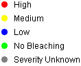
Coral Bleaching
Coral bleaching is a major phenomenon affecting coral reefs around the world. An initial database of bleaching observations was compiled by UNEP-WCMC using a variety of sources. This database has been expanded by ReefBase at the The WorldFish Center, using information from the ReefBase database, the Great Barrier Reef Marine Park Authority (GBRMPA), the CoralList, and other sources of information. This dataset also includes observations indicating no bleaching.
Data Sources
Coral Diseases
Data on occurrences of coral diseases originated from the Global Coral Disease database, by UNEP-WCMC. This database was compiled using disease observations and has been expanded by ReefBase using information from a variety of sources.
Data Sources